We fly your jobsite on a schedule and send you the photos, so you can see what changed this week without driving out to look. Phoenix construction drone photography handles that part for you. Sites move fast: In one week, the grading can move forward, and a foundation can get poured. The structure keeps rising. Equipment ends up somewhere else on the lot, and one subcontractor hands the job to the next for a new phase. Owners and developers can’t be out there every day, and neither can general contractors or project managers, so keeping track of it all gets hard.
Here in Phoenix, most of that work sits on open ground under a strong sun. Few people want to walk a site in the middle of summer. At Corporate Capture, our scheduled flights let you watch progress from a distance and keep a record of site conditions. You can keep your stakeholders informed from almost anywhere, too.
What Does Phoenix Construction Drone Photography Show That Ground Photos Miss?
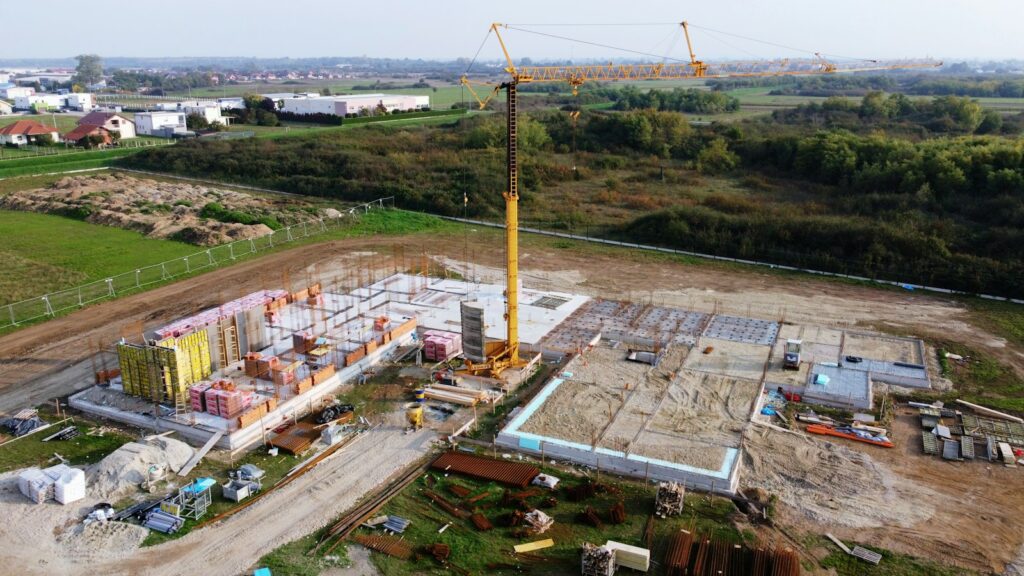
Buildings, equipment, fencing, and stacked materials block the view, and the terrain hides even more on top of that. We take the whole jobsite in one frame from the air. Nothing stays out of sight behind a parked machine or a pile of materials when the photo comes from above, and because the image is high resolution, the specific areas you care about still come through clearly.
Ground photos still have a job to do. They just can’t always show you the complete picture. Professional construction aerial drone photography gives your team another angle on grading and building progress, on where equipment and materials are sitting, and on access roads, parking areas, drainage, and every other condition that shifts as the work moves along.
Watch the drainage. We tell that to clients here in Phoenix, because a summer monsoon storm can drop a lot of water on a graded site in a short time. Our overhead photo shows where that water went far more clearly than a written note can.
Owners and stakeholders can open the photos and see what’s happening on site for themselves, so they aren’t depending on written progress reports alone.
Can You Monitor Construction Progress Without Visiting the Site?
Yes. You pick the schedule, whether that’s weekly, biweekly, monthly, or at important milestones, and our flights send you updated construction progress photos on it. From then on you follow the job from your office or from almost anywhere in the country. Not having to make the trip is one of the biggest advantages of drone progress monitoring.
Who uses it most? The people who have the hardest time getting there. Some of the owners we fly for live in another state, and developers often have several projects going at once. Executives and investors rarely have time to visit every site regularly.
How often we fly is the main thing you decide. Two questions settle it: how fast is your site changing, and how often do your stakeholders expect an update? Once that’s set, the recurring flights take the place of the site visit for every one of those people. The photos arrive on a steady rhythm, and your view of the project stays current even in a week when nobody got out there.
Building a Visual Timeline From Groundbreaking to Completion
We fly from the same spots every time, at the same angles and the same altitude. Done that way, the photos stack into a timeline that follows your project from the first site work all the way to the finished building. Snapshots grabbed from wherever someone happened to be standing can’t do that, because nothing lines up from one picture to the next.
Take one spot on your site and picture it at each of these stages:
- Site preparation
- Grading
- Foundations
- Vertical construction
- Roofing
- Exterior work
- Paving
- Project completion
Lined up in order, those photos become a historical record of the job. You can pull from it for project updates and owner reports, for presentations and meetings, and for future reference.
Contractors get marketing material out of the same images, and it’s excellent material. Construction progress photography turns into before-and-after images, progress videos, website content, presentations, and social media campaigns. Do you build in Scottsdale? Our construction aerial videography page shows how we put the video side together.
Aerial Photos Keep Owners and Stakeholders on the Same Page
Everyone on a project can look at a current aerial photo and see the same thing. A written report doesn’t give you that. Owners, developers, general contractors, architects, engineers, subcontractors, lenders, and investors can all be on one job, and each of them reads drawings, schedules, spreadsheets, and written reports a little differently. A drone photo shows the progress as a picture, and a picture is easy to pass around.
During a virtual meeting, the project manager can put the latest aerial photos on screen so everyone reviews the completed work at the same time. Nobody spends the call trying to describe what the jobsite looks like.
When everyone sees the same image, communication gets better. People leave the meeting knowing what the site looks like right now and where the whole project stands.
Documenting Site Conditions With Dated Aerial Photos
Every professional drone flight we run leaves you a dated visual record of the project. If a question comes up later about site conditions, construction progress, material locations, completed work, or the condition of one particular area, you can go back to the archived drone photos and check for yourself.
The record only holds up when the flights run on a schedule. Photos taken whenever someone remembers leave long gaps. A planned drone program builds a far more complete record than occasional photos ever will, so we build recurring flights into our construction site drone photography work. Your documentation runs on a calendar instead of on somebody’s memory.
Construction Drone Work From Corporate Capture in Phoenix
Every job we fly has an FAA Part 107 certified drone pilot at the controls, whether the site is in Phoenix or somewhere else in Arizona. Corporate Capture puts professional commercial drone operations and professional photography expertise on the same flight. For as long as your project runs, we can keep recurring flights going that shoot your site from consistent viewpoints.
The pilot who shows up at your construction job holds an FAA Part 107 certificate, the Federal Aviation Administration’s certification for commercial drone pilots. That same pilot knows how to compose a strong photograph, so you get both skills in one person.
Some of your stakeholders may be in Phoenix and some across the country. All of them get professional aerial imagery that plainly shows how the project is moving along. We fly sites farther out in the state as well, and if your team is in Mesa, take a look at our construction site drone photography in Mesa work.
Keeping Your Project Visible From Anywhere
You don’t have to stand on the jobsite to know what is going on there. From the start of the job through completion, our professional construction drone photography keeps your project visible and documented. The photos are there whenever you want to pull them up.
Drone Progress Photos: What Owners and Contractors Ask Us
How often should a construction site be photographed by drone?
Go by how fast the site is changing. We can fly it weekly, biweekly, or monthly, or we can come out only for the important milestones. Tell us how often your stakeholders want to see progress, and we’ll set the flights to match.
Are your drone pilots certified?
Yes. Nobody flies your site for us without an FAA Part 107 certification.
Can people outside Arizona see the progress photos?
Yes, and that’s one of the main reasons owners set up a program with us. Someone across Phoenix and someone across the country open the same aerial imagery and see the same progress on the project.
Why do you photograph from the same spots on every flight?
You can hold one flight up against the next. We fly the same locations and angles at a consistent altitude every time, and the photos line up into a visual timeline from site preparation through completion. Photos shot from random angles won’t line up that way.
How much does a recurring drone photography program cost?
We price each program after we talk through your project. Call us, tell us about the site and how often you want us to fly, and we’ll put a quote together for you.
Do drone photos help if questions come up about site conditions later?
They do. We date every set of drone photos we archive. If someone asks later about site conditions, completed work, or where materials were stored, open the set from that date and see for yourself.
Start Your Flight Schedule Before Site Prep
Book your recurring drone flights before site preparation starts, so the first photos show the ground as it was. A visual timeline is only complete if it starts at the beginning. We fly weekly, biweekly, monthly, or at milestones, and we hold the same viewpoints from the first flight through completion.
If you have a project coming up, call Corporate Capture. We’ll talk through a recurring drone photography program for your next Phoenix or Arizona construction project.